Qing Dynasty Geography
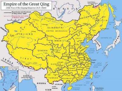
 During the time of the Chinese Qing Dynasty (1644-1911), the nation expanded steadily, reaching roughly its modern borders at the end of the period. The major exception was in the north, where the divisions between prefectures differed considerably along the modern border with Mongolia.
Territory in the North
In the northeast, territory was lost to Russia in 1858. The Illi Basin, around Lake Baikalsh in the northwest, was occupied by the Russian Empire in 1871, but returned under the Treaty of Saint Petersburg ten years later. Most of the Qing Empire was made up of provinces divided into prefectures, although certain regions close to borders were further divided into subprefectures.
Yellow and Yangtze Rivers
As the population of China grew to 400 million at the height of the Qing period around 1800, an effective transport and supply network became ever more vital. Among the greatest trade arteries was the Yellow River, which runs from Qinghai Province's Baiyan Har Mountains for more than 3,000 miles through western and central China, eventually emptying into the Bohai Sea, close to the city of Dongying.
The Yangtze River, even longer than the Yellow, also proved increasingly important, especially as the industrialization of China began to make its presence felt in the 19th century.
Mountains and Deserts
The most fertile and populous region of Qing China lay in the east and southeast, in a wide crescent of land running from Beijing in the north down to the border with Vietnam. The empire annexed much of the eastern part of Tibet in the 18th century, bringing the southwestern border of the country up against the Himalayas.
This range provided an effective barrier against invasion from India to the south, although it also militated against any further Qing expansion in that direction. The Chinese empire was also constrained from significant further growth in the north, thanks to the deserts of Taklimakan and Gobi, both hostile and rocky expanses.
